
Book review Figures, Infrastructures. An Atlas of roads and railways, B. Cattoor, B. De Meulder
Beatrice De Carli
The paper analyses the volume Figures, Infrastructures. An Atlas of Roads and Railways, composed by Bieke Cattoor and Bruno De Meulder, and published by SUN Architecture in 2011. The review delves into the book’s structure, and briefly highlights the scope of the volume on the background of current designerly research on both the fragmented territories of today’s urbanized regions (in Belgium and beyond), and the capacity of infrastructure to generate spatial configurations at multiple scales. At the same time, the article puts into focus the volume’s ability to form new insight into the capacity of mapping practices to ‘set the stage for the inauguration of new worlds’ (Shannon, 2008: 107), and finally ‘remake territory’ (Corner, 1999: 213).
EXPLORATIONS ON/BY MAPPING
Simultaneously delicate in graphics and provoking in the challenges it poses, the sophisticated hardcover composed by Bieke Cattoor and Bruno De Meulder fits in a series of urban-minded publications elaborated by the research group on Architecture and Urbanism (OSA) at KU Leuven, Belgium, and published by SUN. Much is displayed in 175 pages: (re)mappings, commentaries, present-day photographs, historical atlases. The book opens with a detailed explanation of the logics underlying the volume’s own arrangement – thus implying a strong methodological focus on issues of map-making, and the potential designerly repercussions of the de-constructing and re-figuring operations displayed. Subsequently, it develops both an in-depth visual/spatial exploration through the history and present conditions of the territory comprised between the cities of Kortrijk and Ghent in Flanders, and a compelling investigation into the agency of infrastructure as a means of territorial organization.
TOPOLOGY VS. TOPOGRAPHY
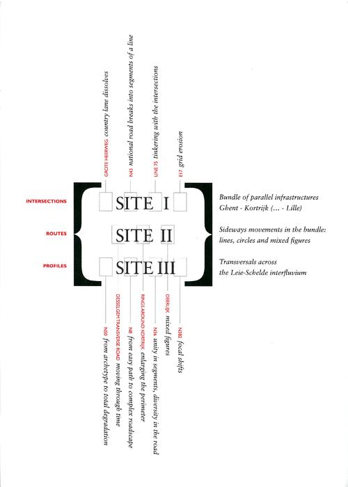
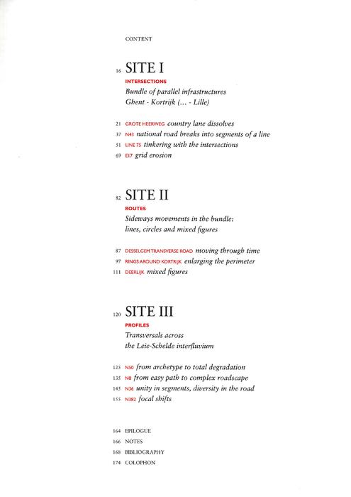
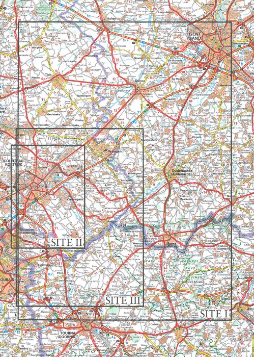
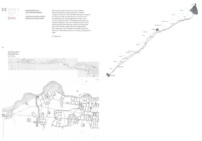
As illustrated by the Authors, the book is «a re-cartography of sections E-16 to H-18 of the Michelin roadmap n.533 ‘regional Benelux’» (image n.4). Throughout the volume, the descriptive content of a single map «is recomposed in the format of a book, and becomes an atlas»[1]. Following a simultaneously complex, and extremely coherent logic of narration, the atlas is articulated into three sections (named Site I, Site II, and Site III), and a graphic Epilogue (image n.2). The volume’s underlying logics are clearly illustrated in a Prologue: first and foremost, the book substitutes the descriptive, ‘topographical’ reference system of the Michelin roadmap, with an interpretative, ‘topological’ approach. Whereas the Michelin roadmap preserves the absolute positions of lines, objects and spaces, and comprises them into a single-page layout, the map series by Bieke Cattoor de- and re-assemble the same physical elements on the basis of their relative positions in space and time. Three main discursive figures are at the basis of this operation, each corresponding to one of the Sites, map series, and sections of the atlas.
The first figure (image n.6) is based on spatio-temporal criteria. It explores the extended bundle of infrastructural links connecting Kortrijk and Ghent, and comprised between the rivers Leie and Schelde. The Site/section carefully disentangles the bundle as a simultaneously spatial and chronological sequence of parallel strings (and related intersections) that run from south-east to north-west – each of them holding a distinct role in both the territory’s history, and its unremitting physical re-arrangement. Two main figures summarize this section: the double-comb, and the ladder.
The second section follows a rigorous spatial criterion of cartographic de-/re-structuring, as Site II re-interprets a fragment of the same bundle of infrastructures by means of depicting the macro geometric elements, and spatial organization codes, which compose it: lines (straight routes), circles (curved ones), and mixed figures (image n.7). In so doing, the section explicitly «outlines the principles of an infrastructural syntax» [2].which is based on physical configurations, rather than functional categories (country lane, national road, railway, motorway).
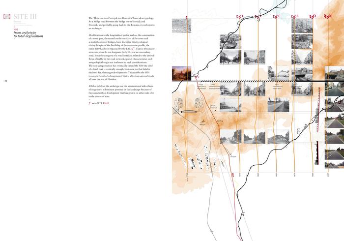
Shifting again scales, Site III takes the form of two ‘double diptychs’, and isolates four national roads running perpendicularly to the above-mentioned ‘double-comb’ figure, north-east to south-west (image 8/8). The map series compares the diverse geneses, and evolutions, of these (supposedly analogous) infrastructural links – each double-diptych focusing on a different aspect of their spatial formation: the relations between national roads and topography on the one hand, and the apparent contradiction between the straightening of the road, and the construction of bypasses, on the other.
MAPPING CONTEMPORARY (BELGIAN)
(INFRASTRUCTURAL) URBAN LANDSCAPES
The re-cartography displayed by Figures Infrastructures creatively draws from the tradition of ‘descriptive urbanism’ – as inaugurated by Bernardo Secchi in his seminal text, Urbanistica Descrittiva (Secchi, 1992).
The book patiently digs, sorts, and re-compiles in time and space the overlaid sets of infrastructural patterns composing the Kortrijk-Ghent ‘bundle’ of today. In that way, the atlas successfully exposes the inherent ordering logics, and hidden potentials, of (a section of) the never-consolidated Flemish region – a highly dynamic and urban conglomeration whose spatial features are «permanently emerging» (De Meulder, 2008: 29). Not unlike many other European «promiscuous landscapes» (Cosgrove, 2007: 35), the Flemish region is often too synthetically described as an amorphous entity, whose apparent cacophony is the exclusive product of today’s urbanization processes. Countering such simplistic criticism of the spatial outcomes of contemporary urbanism, the appealing visual enquiry unfolding throughout the volume asserts in its place that a simultaneously empirical, and diachronic understanding of physical form on the large scale can provide precise insights into the territory’s own (latent) structuring potential, and its embedded capacity for modification.
At the same time, by probing the infrastructural component of the transformative dynamics of (Belgian) urban landscapes, the book touches on a variety of issues and stances concerning the interplays between infrastructure, landscape, and urbanism. The maps and texts presented equally track infrastructure as a physical, measurable object, and an organizing device in the territory. By this means, the atlas assembled by Cattoor and De Meulder can be simultaneously ascribed to a broader field of research, delving into the agency of infrastructure as a means for both (re)structuring space, and generating place, across multiple scale-levels [3].
The two main issues addressed (the reinterpretation of present and past physical traces; the inter-scalar emphasis on infrastructural systems) finally cluster in an effective plea for mapping as an instrument for new forms of regional design and plan making. Figures Infrastructures thus joins, from a singular and cultured perspective, a larger cross-disciplinary discourse advocating for new investigations into the capacity of mapping to act as an agent of spatial change. And it does so in clear designerly terms. By means of deconstructing the ordering logics that determine the territory’s coproduction, the atlas charts as many embedded possibilities for intervention, and finally alludes for a potential project on the region – simultaneously posing mapping as a subject of critical reflection, and a powerful projective device.
FOOTNOTES
[1] B. Cattoor, B. De Meulder, Figures Infrastructures. An Atlas of Roads and Railways (SUN Architecture, Amsterdam, 2011); p.4.
[2]. Op.cit.; p.85.
[3]. The relations between landscape and infrastructure have been extensively investigated by Kelly Shannon and Marcel Smets in The Landscape of Contemporary Infrastructure (NAI Publishers, Amsterdam, 2010). In the Italian context, an in-depth study of the territorial agency of infrastructure can be found among others in the In.Fra volume series published and distributed by Marsilio between 2002 (Atlante and Manuale) and 2006 (Esperienze).
REFERENCES
Corner J., 1999, “The Agency of Mapping. Speculation, Critique, and Invention”, in D. Cosgrove (ed.), Mappings, Reaktion Books, London, pp.213-252.
Cosgrove D., 2007, “From Palladian Landscape to Città Diffusa: the Veneto and Los Angeles”, in Z. Roca, T. Spek, T. Tarkenli, T. Plieninger and F. Hoctl, eds., European Landscapes and Lifestyles: The Mediterranean and Beyond, Edições Universitárias Lusófonas, Lisbon, pp.33-44.
De Meulder B., 2008, “Old Dispersions and Scenes for the Production of Public Space. The Constructive Margins of Secondarity”, Architectural Design, vol.78, n.1; pp.28-33.
Secchi B., 1992, “Urbanistica Descrittiva”, Casabella, n.588, pp.22-23.
Shannon K., 2009, “The ‘Agency of Mapping’ in South Asia: Galle-Matara (Sri Lanka), Mumbai (India) and Khulna (Bangladesh)”, Footprint, n. 2, pp.105-119.
Beatrice De Carli teaches landscape and infrastructure design at the Polytechnic University of Milan. Her PhD thesis (2011, ‘Between Permanence and Change. Decoding and Reframing Residuality: a Case in Milan’) was developed at the Polytechnic University in collaboration with KU Leuven, ASRO/OSA. She studied architecture in Milan and Delft.

This is a review for:
[Book] Figures, Infrastructures
An Atlas of roads and railwaysby Bieke Cattoor, Bruno De Meulder
Related articles:


Planum
The Journal of Urbanism
ISSN 1723-0993
owned by
Istituto Nazionale di Urbanistica
published by
Planum Association