Cultural Heritage: Lucca (Italy)
Structure planning of Lucca
Municipality of Lucca
Context
The structural planning of the Comune di Lucca fixes the targets and the regulations pertaining to the land use aspects of local urban planning. This planning follows the regional legislation and the urban regulations that set out the land use. for forty years from the original town planning scheme, through a new planning phase and to new territorial management. The structure planning is based on a scheme drawn up in 1996-1998 by a group of experts and completed, together with the projects and aims, in 1998-2000 by the Ufficio Pianificazione dell'Amministrazione Comunale (local administration office for planning), managed by the architect Maurizio Tani in collaboration with the architect Leonardo Benevolo and the Benevolo Office of Architects. The urban planning was completed in June 2000 and approved by the Consiglio Comunale in December 2000. Now, according to law, the comments of the state-run institutions, the citizens and other institutions have been received and the planning is awaiting ratification. Lucca is one of the nine provinces of Tuscany. It has 85,000 inhabitants living on a territory of 185,53 square km.
Cultural heritage, protection and development
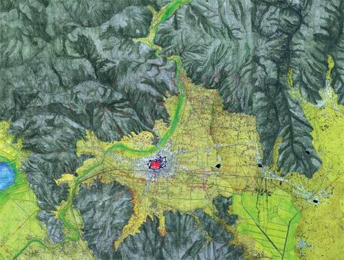
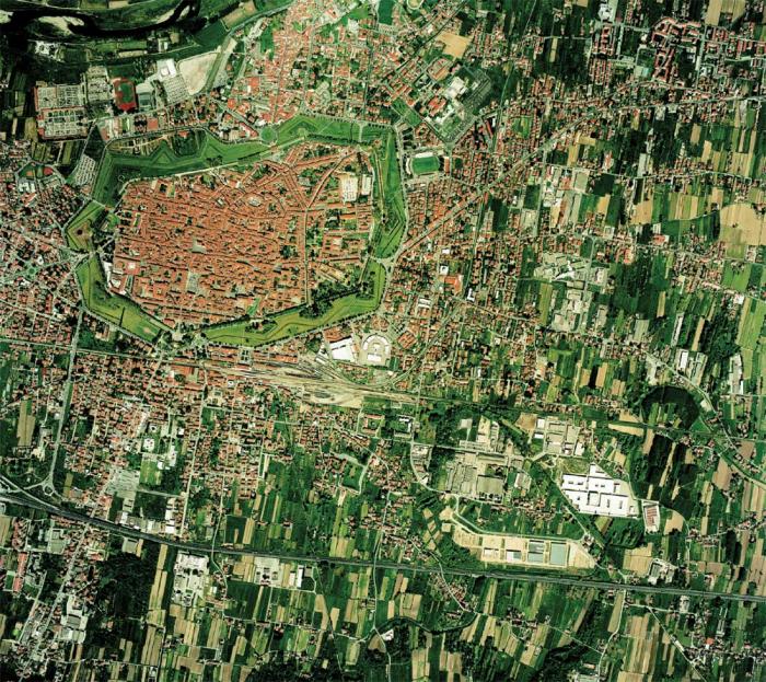
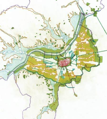
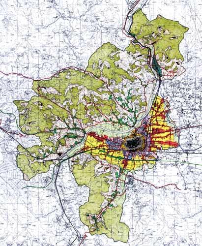
The planning is based on the present geography, characterised by flat and hilly areas typical of Lucca's territory. The Western plain, in the form of 'Carabiniere's hat', which has been levelled out over the years by the several river beds, is the lower reaches of the Serchio river and is surrounded by hills. The old town is situated on the plain: it is near the river and not very far from the western border. Near the border there are many small villages. The relationship between Lucca and its territory is very close. During the Roman settlement, the town was linked to the territory by the Castrum. In Medieval times, the corti were born: small rural settlements that copied the urban central settlement. The only other city with this structure is Venice, which is cut off by the lagoon. The city centre cannot be called a real old town: it is a city with urban and suburban areas, open spaces, streets and its own land surrounded by city walls. It is very different from Siena and Perugia. The monuments and the buildings cannot be separated from the whole structure. The platform in shape of Carabiniere's hat has unusual features. In ancient times, when the land was cultivated, there was a complex settlement system, built by the network of roads (originated by the union of Roman roads and the Medieval ones) and by the corti. But this settlement system was not expanded in an unbridled way. The original structure was very important and it had to be retained. It would be very interesting to build, outside the old town, an urban settlement in shape of a wheel, alternating with cultivated land and roads that would cover a very wide area. This project would allow the environment to be preserved and open spaces to be emphasised to create special views.
Challenges and programme
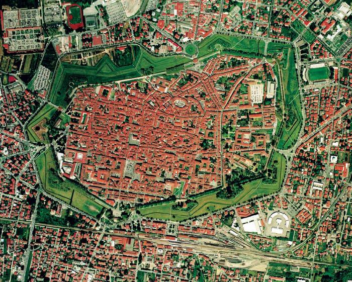
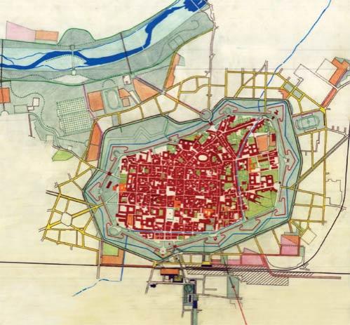
The main target of the project is to respect the geographical structure. This is the identification mark of the territory of the Comune di Lucca situated on the plain. Starting from this idea, the planning is developed to protect the environment, reorganise the settlements and modernise the infrastructure network. The borders of the plain, featuring the river, will be safeguarded and turned into linear parks. Their role will be very important in modernising the city and there will be recreation areas in the north-west, near the hills, and slightly different ones in the south-east. On the plain, the sunburst shaped structure with its different sectors is very carefully safeguarded. Everything will be fixed and improved to improve agriculture and urban settlements. In the middle of the sunburst, the outskirts that enclose the old town and have lost contact with the countryside, have to be improved internally, safeguarding the characteristics. The old town, because of its importance and beauty, has to be restored and where restorations will not be required, it will be maintained, using modern technologies and the newest equipment to make sure everything possible is done. It is very important to safeguard this unique city. The features of this project can be better explained in the urban regulations at the appropriate scale.
The old corti, pievi and villas system, linked to the new settlements, have the same importance as the old town. Because of a very complex system, where the importance of the environment has to be one of the main objectives along with the citizens themselves, the following principle has to be applied: The plan regarding the settlement system must have priority and it conditions the infrastructure network.
Because of the urban structure of Lucca, with its historic and environmental features, it is difficult to renew the network of roads. The integration between settlements and infrastructure cannot be neglected even if the newest settlements are a long way from the old network of roads.
It is necessary to:
1. Link the old network of roads unobtrusively to a modern one, to reduce traffic in the old network of roads.
2. Build the new roads in the already existing network. It would be wrong to completely build new networks since they will damage the settlements and vice-versa The railway has to be modernized to improve extra-urban transport. Near the town centre, some buses will arrive at the City Doors, avoiding the ring road that will have footpaths and cycle paths. Traffic will be limited. Where possible, there will be covered moving walkways: modern technology for a unique city. Plains and hills, where the settlements are so close to the countryside and cultivated land, the network of roads will be very carefully planned.
Related articles:
- Cultural Heritage: Apeldoorn (The Netherlands)
- Cultural Heritage: Faenza (Italy)
- Cultural Heritage: Genoa (Italy)
- Cultural Heritage: Goerlitz (Germany)
- Cultural Heritage: 's-Hertogenbosh (The Netherlands)
- Cultural Heritage: Metz (France)
- Cutural Heritage: Nancy (France)
- Cultural heritage: Valladolid (Spain)
- Cultural Heritage: Vienna (Austria)
- Cultural Heritage: Zaragoza (Spain)


Planum
The Journal of Urbanism
ISSN 1723-0993
owned by
Istituto Nazionale di Urbanistica
published by
Planum Association