large scale plans & projects regulation urban policies urban growth parks climate change simulation technology smart city premio letteratura urbanistica maps representation spatial planning brownfields sprawl governance participation populations scenarios ecology design collaborative urban design information technology sustainability adi
Street Life: Turin (Italy)
The "Spina Centrale" project
Citta di Torino Divisione Edilizia ed Urbanistica Settore Progetti di Riassetto Urbano
The "Spina Centrale" project (redevelopment plans were approved at the end of 1998) refers to the railway line that crosses the city from north to south and the disused industrial areas along its route. The work will be carried out over a ten-year period, between 2000-2010, with the use of both public and private resources. Work has been started to demolish and improve these industrial areas and interventions along the railway line are already underway.
Context
Turin, chief town of the Piedmont Region (Northern Italy, territorial area covering approximately 2,500,000 m2), has approximately 950,000 inhabitants. The population of the region numbers approximately 4,300,000.
Concrete steps have been taken to implement the main guidelines of the General Urban Development Scheme, which has been regularly revised in the light of continual and constant progress. Indeed, many things have changed since the plan was originally conceived. New spaces are needed to house new production activities, innovative technologies must be used to provide services to businesses and families, new trade laws have been introduced and the city's higher education establishments, namely the university and polytechnic (Engineering and Architecture), have more diversified requirements.
Turin has decided not to associate development with a new period of expansion. Instead, it intends to re-launch the city by converting, completing and reorganising existing built-up areas. Of these, the most important are those that played a leading role in the "industrial city's" previous growth process and which has now fulfilled and concluded its functional cycle. These are the areas of Turin's large industrial complexes that have long-since fallen into disuse; they also include the important 19th-century services that supported the organisation of the modern city.
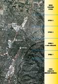
The General Urban Development Scheme has located the 4 areas of the "Spina Centrale" (called "Spina" 1, 2, 3, 4) that constitute the most important complex of disused industrial areas that are suitable for redevelopment. Approximately ITL 2,000 milliard will be invested to redevelop these areas, which cover an area of more than 2,000,000 m².
The railway trench crosses the city from north to south and dates back to the end of the 19th century. In the 20th century it played a strategic role in orientating and promoting the city's development and that of those specific areas located along such an important access route. On the other hand, it also represents a line of separation, a barrier, a fracture in the city as a whole.
The project provided for in the General Urban Development Scheme for the "Spina Centrale" - one of the three main axes that form the basis for large scale redevelopment - exploits the restructuring of the Turin railway link in order to carry out an important urban renewal operation.
The realisation of the Metropolitan Rail Network, the purpose of which is to develop the railway as a public transportation axis at the urban, metropolitan, regional, national and international levels, also involves lowering the rail level. This will enable the surface to be redeveloped, thus eliminating the fracture caused by the railway. The Metropolitan Rail Network project provides for: twelve kilometres of track, seven of which will run underground, crossing the city from Lingotto to the Stura station (from south to north), 7 stations, 2 of which will be new and 3 re-built, 50 million passengers per year, and investments of ITL 2,300 milliard.
This transportation project is innovative in that it also includes plans that valorize urban aspects. Firstly, at the environmental level: the whole distance covered by the railway line will be covered over and a wide boulevard will be created. This constitutes an important factor in terms of image and urban quality. Secondly, in terms of improving connections: the project valorizes the function of the railway link as well as the improvements to urban accessibility provided by the new road axis, which links the existing road network and city.
One of the main objectives of the project is to return reclaimed areas to the city's inhabitants. These areas will be used to develop parks, works of art and wide boulevards because the way in which the inhabitants of a specific neighbourhood or an entire city perceive the various stages of an urban development scheme is essential to the success, or otherwise, of a project.
Challenges
Turin was the first Italian city to develop a Strategic Plan for a ten-year period. Drawn up in collaboration with about 1,000 representatives of the most important public and private bodies, it outlines six strategic guidelines for the city. An association with over 100 members is dedicated to implementing approximately 84 projects contained in the plan.
The City of Turin has also developed an innovative site/laboratory to accompany and explain the urban policies of the Turin metropolitan district. A permanent centre of knowledge, debate and research that integrates with existing national and international networks to interpret the complexities of the contemporary city, where information about territorial projects is stored and made available in order to establish a new form of dialogue with the city's inhabitants and promote Turin's international image. The first step towards implementation of this project consisted of a feasibility study, the results of which portray a lively, interactive, technologically advanced place, designed to involve and inform visitors so that they can discuss and take part in urban redevelopment plans. One of the first products created by the "City Workshop" is the experimental web site (www.oct.torino.it) and the construction of a three-dimensional model of the city of Turin, which includes important projects such as the Metropolitan Rail Network and the "Spina Centrale". A video and CD-ROM illustrating the website have been made available for the 4th Convention in Rotterdam.
The purpose of interventions on the "Spina Centrale" is to transform areas of urban decay, in the central part of the city, from the north to the Lingotto area (in the south), into new urban centres, by physically, functionally and, morphologically integrating parts of the city that are currently separated by the railway trench.
Complex transformations are involved, including the expansion of the universities, the creation of new integrated cultural centres, buildings for the tertiary and advanced production sectors, trade, services, and new residential complexes incorporated into a new system of public spaces that are beneficial to the environment.
The "Spina" axis, which extends outwards into the metropolitan area, is part of a unitary project that combines the potential of the 'underground' railway system with urban renewal at ground level, to reveal a new urban landscape.
Turin will no longer be divided in two. A boulevard with three traffic lanes in each direction (one reserved for public transport) will cross the city. It will have trees along its central island and 9-metre tree-lined borders each side.
Strategy and results
The City of Turin considers the theme of the quality of architecture and public space worthy of particular attention. For this reason, it has appointed a qualified professional architect (selected by means of an international competition) who will be responsible for co-ordinating private and municipal building projects. Urban redevelopment plans concerning the "Spina Centrale" project - drawn up in line with the General Urban Development Scheme - were subsequently examined and are currently being further improved under the guidance of the co-ordinating architect.
In view of this scheme, the city council and other bodies concerned have announced a competition to enable designers to submit proposals for high quality projects for planned new buildings that will eventually characterise the image of the "Spina" itself.
The term for taking part in international competitions for projects for the new Piedmont Region Office Building ("Spina" 1) and the New Civic Library ("Spina" 2) has now expired.
In addition to the "Spina Centrale" area redevelopment scheme, over the next few years new schemes are planned to redevelop more areas that constitute the natural continuation of the "Spina" to the south, namely the Lingotto - Central Market areas. These areas are strategic, not only because they constitute the continuation of the "Spina" along the Metropolitan Rail Network, but for the potential for improvement and redevelopment that, during the 2006 Winter Olympic Games, will distinguish the area as the fulcrum of the Olympic Village.
The "Spina Centrale" project in brief
"Spina" 1
- Territorial area: 142,000 m²
- Gross floor area: 75,800 m²
- Total investment for implementation of public and private operations: ITL 155,393,800,000.
"Spina" 2
- Territorial area: 133,080 m²
- Overall gross floor area (residential, tertiary, university buildings, ASPI (services to businesses)): 50,000 m²
- Gross floor area (library and theatre): 40,000 m²
- Private resources: approx. ITL 112,000,000,000.
- Public resources (library and theatre): ITL 160,000,000,000.
"Spina" 3
- Territorial area: 1,017,700 m²
- Gross floor area: 586,000 m²
- Total investment for implementation of public and private operations: ITL 1,000,000,000,000.
"Spina" 4
- Territorial area: 149,953 m²
- Gross floor area: 87,200 m²
- Total investment for implementation of public and private operations: ITL. 130,386,000,000.
Lingotto
- Territorial area: 1,241,320 m²
- Total gross floor area being redeveloped: 579,323 m²
- Total investment: ITL 1,428,000,000,000.
Related articles:
- Street Life: Cosenza (Italy)
- Street Life: Dublin (Irland)
- Street Life: Graz (Austria)
- Street Life: Groningen (The Netherlands)
- Street Life: Leeds (United Kingdom)
- Street Life: Munich (Germany)
- Street Life: Nijmegen (The Netherlands)
- Street Life: Porto (Portugal)
- Street Life: Regensburg (Germany)
- Street Life: Salerno (Italy)
- Street Life: Strasbourg (France)
- Street Life: Vienna (Austria)


Planum
The Journal of Urbanism
ISSN 1723-0993
owned by
Istituto Nazionale di Urbanistica
published by
Planum Association
ISSN 1723-0993 | Registered at Court of Rome 4/12/2001, num. 514/2001
Web site realized by ChannelWeb & Planum Association | Powered by BEdita 3


