Cultural Identities: Marseilles (France)
'Integrated heritage': an innovative approach
Hélène Balu
The 'Integrated heritage' study constitutes an experimental and innovative approach; it aims to take into account the elements of architectural heritage which, without being exceptional, form part of the context of the inhabitants in their daily lives.
The very notion of 'integrated heritage' is taken from the European Charter for Architectural Heritage, adopted by the Council of Europe in 1975. The European Charter proclaims a number of principles taking into account, notably, new patrimonial values, considerations which are a necessary part of sustainable development and social integration. It thus refers to 'a quality of atmosphere', an 'incarnation of the past' indispensable to 'people's harmony and fulfilment', 'respect for the proportions, form and the arrangement of volumes, and for traditional materials.'
The study is based on a partnership bringing together the city of Marseille , the regional council and the Ministry of Culture and Communication - The Regional General Inventory Department. AGAM ('Agence d'Urbanisme de l'Agglomération Marseillaise') has been given the task by these various bodies of being project manager. Bringing together the inhabitants - with interviews, visits, exhibitions, etc.- constitutes one of the major aspects of this approach.
The context
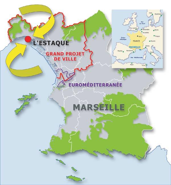
Marseille contains a number of operational zones in connection with major development operations; this is the case with the Urban Grand Project [GPV] in the northern part of the commune.
The 'Grand Projet de Ville' (GPV - Major City Development Project) originally called the Major Urban Project (GPU) is a procedure which was launched at the national scale in 1993. The objective of GPV is to apply a large amount of funding to counter urban imbalances, namely:
• to combat exclusion
• urban infill
• urban restructuring
• exploitation of economic potential and creation of jobs
• improvement to transport facilities and mobility of the inhabitants
The territory to which this process applies involves almost 220.000 inhabitants.
This process involves many projects which will inevitably transform this section of the city. The partners in the project have agreed on the necessity of acquiring a better understanding of the development and urban history of this area before major modifications are made, and applying the integrated heritage approach in the L'Estaque district, within the GPV, which constitutes the experimental territory.
L'Estaque an experimental territory
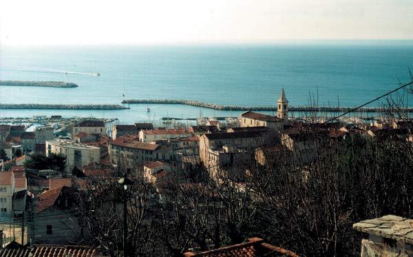
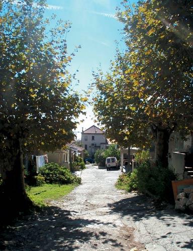
L'Estaque, a seaside village, has a prominent part in the Marseillaise identity, and also constitutes one of the cradles of modern painting: Braque, Dufy, Cézanne, etc. all stayed here at different times.
Situated in the extreme north of the Commune of Marseilles, urbanisation of the Estaque sector is only recent; at the beginning of the 19th century, it was mainly farming land with a few sporadic hamlets, one of which is the village of L'Estaque. However, industrial activity first began to develop with about 30 tile-making plants, already at that time.
Towards the middle of the 19th century, the trend towards urbanisation accelerated considerably: the construction of the railway from Marseilles to Avignon, the development and facilities of the port of La Joliette and the installation of large industrial undertakings; these major developments coincided with a massive influx of population resulting in a major movement towards urbanisation.
The goals
The 'integrated heritage' study must be dynamic: the aim is not to freeze what is already there, but to reveal a process of urban and social development, a way of apprehending the phenomena of the reconstruction of the city in relation to itself, and to include the inhabitants in the quest for knowledge and in the methods of dissemination. This is particularly meaningful in connection with the major developments, economic changes which are shaping the city of the 21st century, and notably in the territory of the Urban Grand Project.
Accompanying these major town planning developments, taking into account the initial basis, both the landscapes and the mentality of the inhabitants of the districts, is the very essence of the 'integrated heritage' approach; the latter is conceived as a genuine process of urban intervention, and as a guarantee against a possible destruction of identity.
Methodology
The approach enables the town planning process which caused the development of this district of Marseille to be reconstructed, starting with the 18th century agricultural hamlet, then located at the limits of Marseille, and ending with its contemporary configuration.
This historical material, combined with the urban anthropology approach, and also with an ethnological approach relating to identities, practices and collective memory, constitutes a point of reference for the cultural development and initiatives directed at the inhabitants, students and researchers.
More tangibly, the study is organised in two sections.
• an inventory section comprising:
- an exhaustive listing of the elements of the heritage
- a photographic campaign of the elements in the inventory
- the transcription of the elements collected and constitution of a database which will be fed into the city of Marseille geographic information system (SGI).
• a 'restitution, development and publication' section, relating the inhabitants of this territory to this approach; the following are offered: exhibitions, slide shows, information leaflets, and ultimately the creation of internet pages, etc.
A first exhibition, 'The church district, l'Estaque', highlighted
• the layers constituting the district,
• the urban form thus outlined in the course of history,
• the outstanding buildings,
• elements throwing light on the toponymy,
• etc.
This first exhibition, staged in the heart of the district, was primarily addressed to the inhabitants of the area; it was accompanied by a slide show which displayed in a more whimsical manner the purposes of this experimental approach.
The 'Church quarter of L'Estaque' is one of the emblematic sites of L'Estaque; clinging onto the relief of the landscape, it dominates the Estaque-beach area still today displaying a topographical background of terraces dating from the agricultural period. During the successive urbanisation movements, 'islands of buildings' started to take the place of vineyards as early as 1819. Through its position on the promontory, the church, erected in 1851, forms the focus of the spatial structure. Urbanisation was often the outcome on the building allotments on land of the former tile making plants; indeed, the working of the clay quarries and manufacture of tiles was for a long period a fundamental activity in this sector; one forming the quarter, but also providing the basis for its history and settlement patterns. The tiles were exported throughout the world; this trade fostered intense maritime activity contributing in particular to introducing new plant species blending into the plants of the area. This urbanisation in the form of building allotments can be seen today in the regular rectangles organised around wide, straight thoroughfares. The place names also represent a record of history; for instance, fishing, which was the other major activity in L'Estaque is recalled to the passer-by in the street names: rue des Pêcheurs, rue de la Rascasse, impasse des Oursins referring to the fishermen, the local species of rockfish, sea urchins etc.
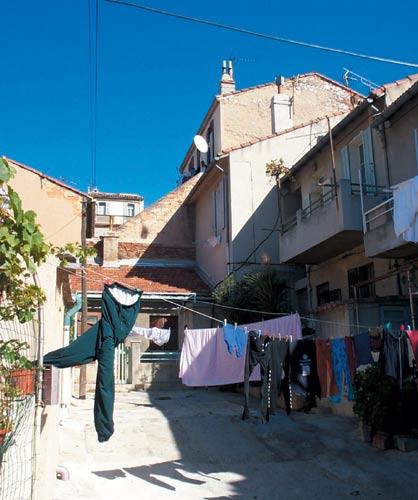
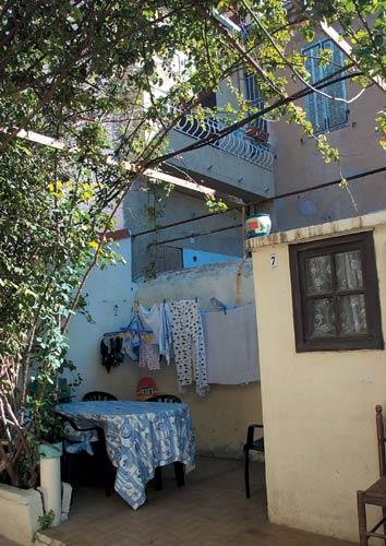
A new exhibition entitled 'The courtyards and alleys of L'Estaque' is now being prepared. This theme presents an original urban form, the traces of which can still be seen today in the structure of this area The courtyard or alley forms living cells organised around a common yard in which common functions are organised: toilets, the linen washhouse, storage sheds,... This exhibition will also highlight a lifestyle -- neighbourly relations and sharing of public, private and community spaces. The slide show will tackle the question of limits: changeover from public space to private and community spaces and lastly to individual private space.
Related articles:
- Cultural Identities: Almere (The Netherlands)
- Cultural Identities: Amsterdam (The Netherlands)
- Cultural Identities: Barcelona (Spain)
- Cultural Identities: Copenhagen (Denmark)
- Cultural Identities: Cosenza (Italy)
- Cultural Identities: Enschede (The Netherlands)
- Cultural Identities: Luxemburg (Luxemburg)
- Cultural Identities: North Rhine-Westphalia (Germany)
- Cultural Identities: "Social Town 2000" (Germany)
- Cultural Identities: Wolfsburg (Germany)


Planum
The Journal of Urbanism
ISSN 1723-0993
owned by
Istituto Nazionale di Urbanistica
published by
Planum Association